Map Switcher Chrome Extension


-
Chrome Extension Page
-
Total Number of Extension users:5K +
-
Reviewed by :21 Chrome Users
-
Author Name:
-
['david.r.edgar@gmail.com', 'david.r.edgar']
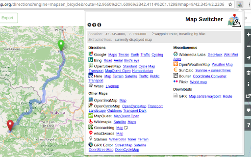
 Switch quickly between online map services.

Open the MapSwitcher extension popup to show the available selection of maps. Click any of the links to open the selected map in a new tab.

Where possible, MapSwitcher supports directions as well as plain maps. It converts coordinates, zoom levels and transport options as far as it can, according to availability in the selected map service.

Ive been prevented from continuing to list here the sites for which input and output is available. You can find a comprehensive list at https://github.com/david-r-edgar/MapSwitcher#mapping-services-supported

Would you like to see a specific other service supported? Are there features missing that would be useful to you? Have you found a bug? Email david.r.edgar@gmail.com or log an issue at:
https://github.com/david-r-edgar/MapSwitcher/issues
How to install Map Switcher chrome extension in chrome Browser
You can Follow the below Step By Step procedure to install the Map Switcher Chrome Extension to your Chrome Web browser.
- Step 1: Go to the Chrome webstore https://chrome.google.com/webstore or download the extension Map Switcher Chrome Extension Download from https://pluginsaddonsextensions.com
- Step 2: Now search for the Map Switcher in Chrome Webstore Search and click on the search button.
- Step 3: click on the Map Switcher Chrome Extension Link
- Step 4: in the next page click on the Add to Chrome button to Download and Install the Map Switcher extension for your Chrome Web browser .
Map Switcher Chrome extension Download
Looking for a method to Map Switcher Download for Chrome then this download link is for you.It is the Map Switcher Chrome extension download link you can download and install Chrome Browser.
Download Map Switcher chrome extension (CRX)
-
Change satellite images in mapping websites.
-
Helps OpenStreetMap contributors to easily switch between different maps and analysis tools from the community.
-
OSINT tool for images. Scans page for images with EXIF metadata, while browsing. Also has context menu options for images.
-
Provides access to certain OS OpenData products within the WME environment
-
An extension for analyzing, interrogating, and troubleshooting ArcGIS REST Services.
-
This extension will allow you to replace Google Maps with another mapping service on any web site.
-
OSINT addon
-
OSINT Swiss army knife:bookmark/record pages, store screenshots, scrape and enrich entities. Finds text on every page + highlight.
-
DumpItBlue is a tool that helps to dump Facebook stuff for analysis or reporting purposes.